LEARN ABOUT the CHEMEHUEVI WILDERNESS AREA at the BLM
VIEW A GEOLOGIC MAP of the TOPOCK 7.5' QUADRANGLE, ARIZONA and CALIFORNIA
RESEARCH BACKGROUND
Geologic faulting and earthquakes go hand in hand, and understanding how and why the crust of the Earth breaks in response to built-up stresses is a fundamental question addressed by geologists. A particular class of normal faults, known for their peculiar orientation, are of particular interest because it is not known whether their movement is accompanied by large-magnitude seismic (earthquake-producing) activity. However, examples of this class of faults are recognized in several environments around the earth, including actively-extending continental crust, mid-ocean ridge spreading centers, and in the eroded roots of settings that have undergone a large amount of stretching (extension) in the past. An excellent location to view the latter is in the southern Basin and Range physiographic province of the western United States, in an area known as the Colorado River Extensional Corridor (CREC). The CREC is ~100 km-wide, and extends from the southernmost part of Nevada and continues south along the California-Arizona state lines. This area underwent significant extension from ~23-12 million years ago, and exposures of the faults that accommodated the crustal stretching can be seen in the many isolated mountain ranges that occur in this region. Our investigation is focused on the Chemehuevi Mountains, SE California.
Despite wide recognition of regionally developed, large-slip, low-angle normal faults (LANF) globally, controversy remains regarding their initiation and protracted slip at shallow dips through the seismogenic crust. Motivated by recent GPS/microseismicity studies on active LANFs and laboratory experiments by colleagues, we have engaged in a 3-year, multidisciplinary field and laboratory structural and isotopic study to document the initiation of a very well exposed low-angle normal fault through intact (homogeneous) quartzo-feldspathic rock exposed in the Chemehuevi Mountains (CA).
Our investigation is based on a macro- and microstructural characterization of natural fault rocks formed during slip on a now-exposed fault system, and combines field, lab, and experimental studies to address processes allied with their initiation. The study site is the near-ideal natural laboratory to address the relationship between internal structure and mechanical behavior of these faults, because:
1) regional mapping conducted previously has established key areas of fault exposure;
2) the footwall is underlain by undeformed granitoids that comprise quartz and feldspar (with minor biotite, muscovite and/or
amphibole), and it can be assumed that the protolith is dominated mechanically by a two-phase (quartz+feldspar) mixture,
3) the fault system comprises multiple low-angle normal faults with variable slip (~2-18 km) that allow investigation of fault zone
evolution from initiation deep under the Earth surface, to maturity as the lower block of the fault was uplifted towards the surface
as a result of extension
4) exposure of the fault system for >20 in the dip-direction, facilitate analysis of spatial variations in deformation mechanisms
through roughly 5 km crust at the base of the seismogenic zone;
5) the thermal history of the footwall at the LANF initiation is well documented, providing an opportunity to examine rocks with
initial ambient temperatures between ~150-400°C.
To help elucidate microstructural evolution and the influence of hydrothermal fluids on fault weakening mechanisms, geologist from Ohio University and the University of Wyoming are conducting field mapping, optical microscopy, image analysis characterization, and stable isotope studies. The integration of field and laboratory (textural and stable isotope) studies of naturally deformed crystalline rocks, with experimental studies by colleagues in Europe, allows this research to cut across disciplinary boundaries in an effort to transform the understanding of frictional-viscous processes and their manifestation in the geologic record, with implications for earthquake hazard assessment within continental interiors
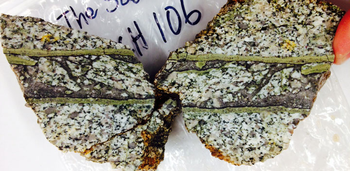
Shear band (cataclasite) from the main damage zone of one of the low angle normal faults exposed in the Chemehuevi Mountains. The green bands mark the upper and lower contact of a 3 cm-thick shear zone, which is a zone of deformation formed when rocks on either side slide past one another in response to applied stresses.
